Satellite Ice Dynamics
The Satellite Ice Dynamics (SID) group at the University of Leeds uses Earth observation data to improve our understanding of ice dynamic change and the processes driving it on the Antarctic and Greenland Ice Sheets and glaciers ice caps in the Northern and Southern Hemispheres. Loss of ice from polar latitudes can affect the Earths albedo, polar atmosphere and ocean circulation, and directly contributes to global sea level rise.
Satellite data has revolutionised our ability to observe change in these remote and inhospitable regions, and our data records are now long enough to enable us to study the physical mechanisms responsible for driving these changes. We work closely with our national and international space agencies, and colleagues in UK and international research institutions, such as the British Antarctic Survey (BAS), National Oceanography Centre (NOC), National Centre for Earth Observation (NCEO) and European Space Agency (ESA).
Research interests
Our primary field of interest is using satellite data to observe the polar regions, particularly Synthetic Aperture Radar (SAR), and radar altimetry. We track visible features such as crevasses to measure how fast glaciers flow, we use interferometry to measure tidally induced flexure if ice shelves at the ice sheet grounding line. Our ice velocity processing system (MEGATHON) produced ice speed measurements in near real time, and we are always excited to establish new collaborations with colleagues interested in these datasets. We use altimetry data to measure ice sheet and ice shelf thickness change, and to study active subglacial lakes found beneath the ice sheet. We have expertise in machine learning which we use to produce a new generation of satellite data products including crevasse maps and calving front location data products.
Satellites used by the group include the ESA-EC Copernicus missions including Sentinel-1 and Sentinel-2, ESA Earth Explorer missions including CryoSat-2 and Biomass, historical satellites such as ESA ERS-1 & 2, and planning for future missions such as ESA ROSE-L.
We use our satellite data in combination with numerical ice sheet models, and our primary tool is the BISICLES Ice Sheet Model developed and maintained by CPOM.
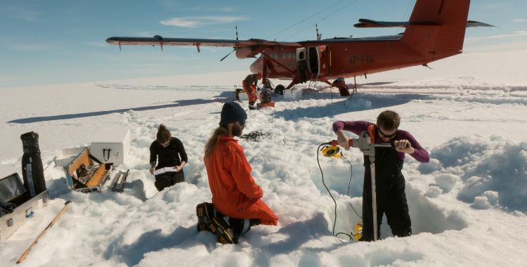
In addition to our satellite based research, we also conduct fieldwork on the Antarctic and Greenland Ice Sheets, and glaciers and ice caps, to calibrate and validate our satellite observations.
Contact us
If you would like to discuss an area of research in more detail please contact the SID PI’s Professor Anna E. Hogg, Dr Trystan Surawy-Stepney, and Dr Benjamin J. Wallis.
Our Research Group team includes: Professor Anna E. Hogg, Dr Trystan Surawy-Stepney, Dr Benjamin J. Wallis, Dr Jacob Connolly, Dr Yikai Zhu, Ross A. W. Slater, Sally Wilson, Mae Evans, Molly Hammond, Ellie Fisher